


In mid-to-late November 2025, Central Vietnam experienced record-breaking rainfall that led to widespread and severe flooding. Heavy and persistent rains pushed water levels to critical alert thresholds, forcing the region’s hydropower reservoirs to discharge at rates exceeding their historical design benchmarks. This article reviews the meteorological background of the event, examines the operational challenges faced by reservoir managers, and discusses how advanced flood simulation technologies can support future risk mitigation.
Beginning in late October and intensifying through late November 2025, a series of extreme rainfall events struck Central Vietnam, including Hue, Khanh Hoa, Da Nang, and Quang Ngai, as well as the Central Highlands provinces of Gia Lai, Dak Lak, and Lam Dong. Typhoon Kamlaegi, which occurred earlier in this season, contributed significantly to the overall hydrometeorological stress on the region.
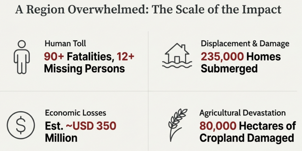
As of November 23, reports indicate at least 90 fatalities, more than 12 missing persons, and approximately 235,000 homes submerged. The region, which is central to Vietnam’s coffee production, saw around 80,000 hectares of cropland damaged. Infrastructure systems, including power networks and transportation, also suffered major disruptions. Economic losses are estimated to approach USD 350 million.
Meteorologically, this was not a typical typhoon-driven disaster. The extreme rainfall resulted from a rare “synchronization” of atmospheric anomalies. A strong cold surge from the north collided with warm, moisture-rich easterly winds, producing a highly unstable convergence zone. Sea surface temperatures 1-1.5 °C above average further intensified convection, similar to the southern coastal low-pressure systems observed in Japan during winter.
The Truong Son Mountain Range, with elevations reaching 2,700 m, also played a critical role. Acting as a natural barrier, it physically forced moist air upward and trapped the rainband over the same area for an extended period. This “topographic lock” led to exceptional rainfall accumulation, far exceeding the region’s natural drainage capacity.

2. Observations of Water Levels and Dam Discharge
Rainfall totals exceeded 1,900 mm in one week and surpassed 1,500 mm within three days in several parts of Vietnam. Such volumes placed immense pressure on river systems, with many rivers surpassing the highest flood alert level (“Level 3”). At the Chong Son station on the Ba River in Dak Lak, water levels peaked at 40.99 m, 6.49 m above Alert Level 3 and more than 1 m higher than the historic record set in 1993. Similar exceedances were observed at the Dong Trang station on the Cai River in Nha Trang and along the Dinh River in Ninh Hoa.
These elevated flows were closely tied to emergency discharges from upstream reservoirs. One major point of concern was the Sông Ba Hạ Hydropower Plant in Dak Lak. Local reports indicate a maximum discharge rate of 16,100 m³/s – higher than the maximum discharge ever recorded even at larger plants such as Hoa Binh or Lai Chau, and significantly above its design benchmarks established after the 1993 historic floods. suggests that the reservoir’s flood-control capacity had effectively been exhausted when the extreme rainfall struck the region. Under the combination of these temporal, administrative and physical constraints of this event, emergence releases may have been the only feasible option to protect dam safety
3. Challenges for Integrated Flood Management
This extreme rainfall occurred during the seasonal transition from the rainy period to the dry period. For hydropower and irrigation reservoirs in Vietnam, this is a crucial time when operators aim to maximize water storage to support electricity generation and agricultural demand during the coming dry months. This structural incentive may have constrained the ability to conduct early preventive releases.
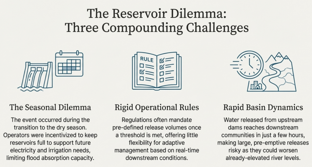
An additional challenge lies in the administrative front. As Dr. Nguyen Quoc Dung, Vice President of the Vietnam Association of Dams and Water Resources Development, noted, while the public may question reservoir managers and regulators for accountability, the reality is that many localities lack the hydrological expertise needed to guide optimal, risk-balanced release decisions. In practice, regulations often specify that once water levels reach a designated threshold, operators should release a predefined volume. While providing operational clarity, such rules allow little flexibility to adjust releases based on real-time downstream flood conditions. The lack of local capacity as well as the rigidity of existing rules have increased the difficulty in making holistic decision-making.
Furthermore, in the case of this 2025 Central Vietnam event, the basin’s topography and geographical conditions meant that water released from upstream reservoirs would reach downstream areas within just a few hours. Even if operators had attempted early preventive release, such discharges may have risked triggering inundation in the downstream where the water levels were already elevated from the recent rainfall events.
Under the combination of these temporal, administrative and physical constraints of this event, emergence releases may have been the only feasible option to protect dam safety. Whilst this highlights the intrinsic challenges of integrated flood management across an entire river basin, it also underscores the significant potential value of improving hydrological forecasting tools that can offer longer lead times and more reliable guidance for pre-emptive actions.
4. Implications for Flood Simulation Technologies
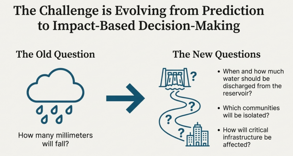
As rainfall patterns become increasingly erratic under climate change, and as urban expansion, agricultural water needs, and electricity demands grow, the need for accurate and actionable information becomes even more pressing. Future flood risk management requires moving beyond simple rainfall forecasts (e.g., “how many millimeters will fall”) toward impact-based risk assessments that can answer more practical questions, such as when citizens and industries will face inundation, which communities may be isolated, and how critical infrastructure might be affected.
In particular, the Central Vietnam floods raised the need for systems that can support administrative decision-making for reservoir operations, as such upstream discharges would directly affect the downstream flood risk as well as basin-wide irrigation and electricity supplies. Rapid, data-driven guidance, powered by reliable forecast models linked to real time hydrological observations, will be essential to answer “when and how much water should be discharged from the reservoir” for future emergency situations.
At Aqunia, we aim to contribute directly to these needs. Our high-resolution flood-simulation platform provides detailed predictions of river flow, water levels, and inundation extent at any location, including reservoir sites, downstream floodplains, and urban areas. When combined with precise hydrological data and advanced reservoir-operation modeling, our system can support both long-lead forecasting and real-time decision workflows. We believe such integrated technologies will be indispensable for managing fast-evolving, high-risk flood events in a changing climate.
5. Conclusion
The 2025 floods in Central Vietnam represent a tragic example of the emerging “new normal” under climate change. For disaster-management stakeholders, the event highlights the necessity of moving beyond existing hydraulic models and approaches. The future of reservoir operations lies in integrating high-resolution and real-time simulation technology into region-specific decision-makings, enabling a more responsive approach to disaster management.
References
- The Guardian (23 November 2025). Vietnam flooding death toll reaches 90 amid landslides and relentless rain https://www.theguardian.com/world/2025/nov/23/vietnam-flooding-deaths-landslides-rain-dak-lak
- Voice of Vietnam (22 November 2025). Rare weather phenomenon unleashes historic flooding in Central Vietnam https://english.vov.vn/en/society/rare-weather-phenomenon-unleashes-historic-flooding-in-central-vietnam-post1247952.vov
- VietnamNet Global (20 November 2025). Record-breaking floods engulf Central Vietnam, inundating six provinces https://vietnamnet.vn/en/record-breaking-floods-engulf-central-vietnam-inundating-six-provinces-2464773.html
- Dantri (19 November 2025). Song Ba Ha Hydropower Plant increases discharge to 16,100m3/s, flood forecast to exceed 1993 historical level https://dantri.com.vn/thoi-su/thuy-dien-song-ba-ha-tang-xa-len-16100m3s-du-bao-lu-vuot-lich-su-1993-20251119184212570.htm
- Lao Dong (23 November 2025). Flood discharge at Ba Ha River and current regulations on reservoir operation https://news.laodong.vn/moi-truong/xa-lu-tai-song-ba-ha-va-quy-dinh-ve-van-hanh-ho-chua-hien-hanh-1614121.ldo